Get your zip code's Risk Score
Scored 0 to 100 on the Basement Risk Index across metro Detroit, Wayne, Oakland, and Macomb counties.
Why this exists
In June 2021, storms put tens of thousands of metro Detroit basements underwater in a single weekend and brought a federal disaster declaration to Wayne County. Most homeowners had no idea their street had a history. The records existed the whole time. We are a southeast Michigan team that pulled them together so you can see your neighborhood's history before the next storm, not after.
- Every score traces to public records, and the full methodology is published
- Suburban scores are modeled from housing data and clearly labeled, never presented as measured flood counts
- Free for homeowners to use, with no signup and no data resold
Basement risk across southeast Michigan
Warmer areas carry more recorded or modeled basement flooding risk. Detroit is scored from more than 13,400 municipal records; surrounding suburbs are modeled from housing age, 2021 storm impact, and sewer-era factors.
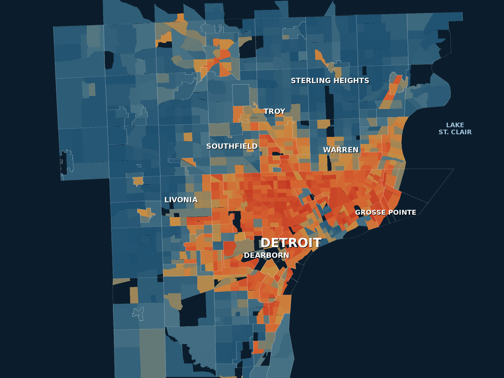
The Basement Risk Index rates 1,100 neighborhoods and 116 communities across metro Detroit. A model of relative structural risk built from public housing and flood data, not a prediction for any single property. How the Index works →
Read the 2026 findings: which communities flood, and why →
Why southeast Michigan floods
Clay soil, 60-year-old drain tiles, and the same streets every storm
Basement flooding here is not bad luck. Heavy clay soil holds water against foundations, and much of the housing stock around Detroit was built before 1965, with drain tiles that have been failing quietly for decades. Homeowners usually find out the hard way, after the drywall is soaked and the furnace is damaged, when an insurance adjuster explains what a groundwater exclusion is.
Catching the problem early is the entire game. A sealed crack or corrected grading runs a few hundred dollars. The same water, left alone through one more freeze-thaw winter, becomes an $8,000 to $20,000 excavation.
How to use this
See your Risk Score and the actual report count near you.
See the decade-by-decade housing data and how your block compares.
A sealed crack today costs a fraction of an excavation next spring.
Explore the data
A free, open homeowner resource. No signup, no login, nothing sold.
Common questions
Is this really free?
Yes. The Basement Risk Index and every community report are a free, public resource. There is no signup and no login.
Where does the data come from?
Two public sources. For the city of Detroit, we use more than 13,400 documented water-in-basement reports filed with City of Detroit Improve Detroit / 311, retrieved June 2026, plus Census housing-age data. For suburban communities, the score is modeled from U.S. Census housing-age measures; no municipal flood records are integrated there yet. Our full methodology spells out exactly what is measured versus modeled.
I live in the suburbs. Does this apply to me?
Yes. We score 116 communities across Wayne, Oakland, and Macomb counties. Suburban scores are modeled from housing age and regional factors rather than local flood reports, which we label clearly. Find your community on the interactive metro map or in the full ranking.